
The Roosikrantsi Street area is historically very important in Tallinn. It has been a coastal area, an important exit from the city, and part of the modern city center. Its entire history lies buried under nearly three meters of asphalt. Several archaeological excavations have been carried out in the area, and it can therefore be assumed that Roosikrantsi Street hides historical artifacts from different periods.
TASK
Renovation work is about to begin on Roosikrantsi Street, including the reconstruction of the public water supply and sewerage systems. Before the excavation work could begin, a preliminary heritage survey of Roosikrantsi Street had to be carried out to identify areas where objects of heritage interest might be found. The task of the GPR survey was to find anomalies indicating archaeological objects that were not related to utility networks and to distinguish areas untouched by excavation work related to utility networks, where better preservation of layers of interest for heritage protection could be expected.
SOLUTION
A high-resolution 3D GPR Raptor cart version with a 450 MHz antenna array with 8 cm spacing between antennas and scanning 8 profiles in a single pass was used for data acquisition. Raptor is a new generation 3D GPR that uses the best Real-Time Sampling technology. This ensures good resolution and a low-noise image. Data post-processing was performed using Condor, a new software developed specifically for processing and visualizing Raptor data. The fast and high-resolution data acquisition of the Raptor 3D ground-penetrating radar and data processing with Condor software enabled the observation of underground objects on Roosikrantsi Street from all directions.
RESULT
The GPR survey revealed what lies beneath the asphalt layer on Roosikrantsi Street. It was clear that a lot of excavation work had been carried out on the street and that there were many utility networks in the ground. The images obtained with the GPR were compared with a previously compiled geodatabase to identify underground objects that were not related to utility networks. Several smaller anomalies were found in places where, according to the geodata, there should be no utility networks. In addition, the underground remains of what is believed to be a large building were found in the part of the street closest to Vabaduse Square.
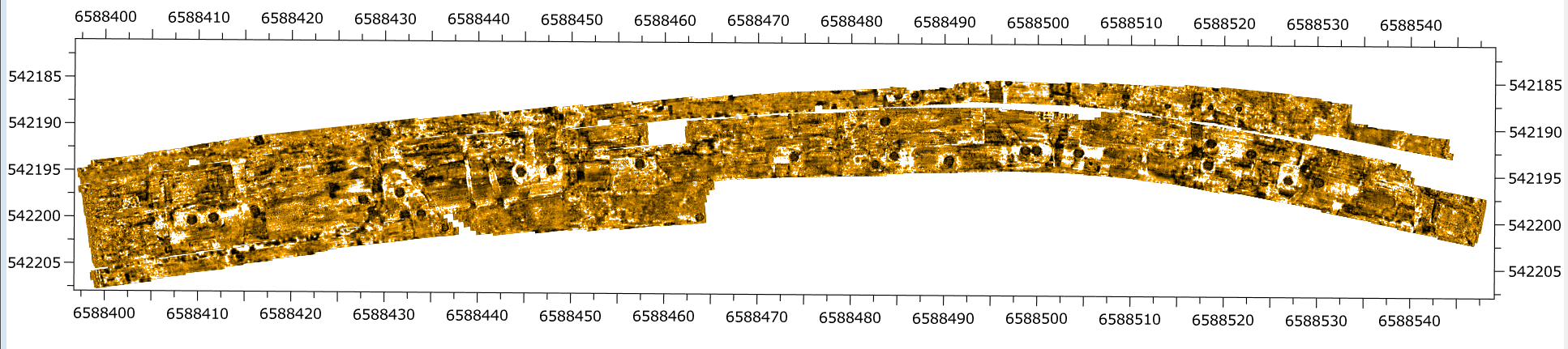
Anomalies found with GPR in horizontal section of ground surface