Accurate and reliable information about underground utility networks is important – all designers and builders know this. It helps prevent accidents, avoid unplanned costs and save time.
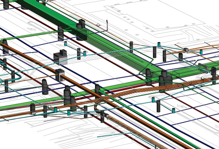
A few years ago, a project completed by the City of Tallinn, „Creating a prototype technological solution for 3D data monitoring of underground structures“ concluded that with the right equipment and methods, it is possible to accurately map virtually all underground structures. The knowledge gained during this project will be gradually implemented into everyday activities.
For example, the Tallinn Environment and Public Works Department is currently conducting a tender for the preparation of the Rahu tee main project. Among other things, the contractor must investigate the location and depth of existing utility networks in the survey area. The exact locations and depths of all utility networks must be marked on the plan and 3D models of the existing utility networks must be created in LandXML format.
It is widely believed that it is not possible to obtain accurate data on underground utility networks. This assumption was partly true years ago. Today, technology has advanced to such an extent that it is possible to obtain accurate and reliable data on underground utility networks. This requires motivation and the use of the right equipment and methodology.
An innovation project carried out by the City of Tallinn concluded that there is no single super device that can accurately map all underground pipes and cables. The right tool must be selected for each job or situation, and in most cases, several devices must be used together in the same survey. It was also concluded that in most cases it is not possible to map underground utility networks without GPR. GPR can detect both metal and non-metal utility networks and also “see” other underground objects that may be important for design or construction work.
Currently, there is no service provider in Estonia that can independently conduct a comprehensive survey of underground utility networks in accordance with the new requirements. All geodesy companies are able to compile a geodetic base from existing data. Many companies are able to detect electrical cables with a cable locator. Some companies are able to carry out well surveys. And we are able to carry out surveys with GPR.
The market is waiting for a comprehensive solution. Today, the City of Tallinn has announced its first tender requiring a 3D model of existing utility networks. We believe that this will soon become standard practice in all infrastructure projects in Tallinn. Similarly, private sector infrastructure developers will soon demand a comprehensive solution. Clients will soon no longer be satisfied with inaccurate geo-databases, but will want to have an accurate 3D model of the underground situation. This will require cooperation between different specialists and will likely lead to the emergence of new companies.
We are open to cooperation and exchanging ideas. If you have any thoughts or ideas about what we can do together, please do not hesitate to contact us!

