What is GPR – Ground Penetrating Radar?
GPR is a high-tech device that can see through the ground, concrete, rock, wood, ice, and even water. Compared to other technologies, georadar is affordable and provides quick and accurate results. GPR survey is fully NDT (Non-destructive Testing), cost efficient way to identify sub-surface objects and features.
We perform GPR surveys
For mapping underground utility networks
For mapping drainage systems
For identifying archaeological sites
For determining soil layers
And much more
What can GPR be used for?
GPR surveys do not break the surface or damage the objects being investigated. This is very important for both communication networks and archaeological research. In addition, GPR can determine the thickness and structure of soil layers and find anomalies caused by pollution, for example. GPR surveys can be carried out anywhere where the survey area can be scanned with GPR.
Areas of application for GPR (ground-penetrating radar)
- Identification and mapping of underground utility networks
- Concrete element research
- Bridge and tunnel structure research
- Road research
- Bathymetric surveys
- Groundwater surveys
- Karst surveys and karst mapping
- Stratigraphic surveys
- Water level surveys
- Identification and mapping of historical buildings and infrastructure
- Identification and mapping of burial sites
- Searching for and mapping artifacts
- Research, assessment, and virtual reconstruction of historical settlements
- Hazardous waste and soil contamination studies
- Waste station studies
- Underground tank and drum studies
- Detection of explosives and weapon caches
- Detection of secret burial sites
- Detection of bunkers and tunnels
- Detection and mapping of unexploded ordnance (UXO)
Areas of application for GPR (ground-penetrating radar)
CIVIL ENGINEERING
- Identification and mapping of underground utility networks
- Concrete element research
- Bridge and tunnel structure research
- Road research
GEOLOGY
- Bathymetric surveys
- Groundwater surveys
- Karst surveys and karst mapping
- Stratigraphic surveys
- Water level surveys
ARCHAEOLOGY
- Identification and mapping of historical buildings and infrastructure
- Identification and mapping of burial sites
- Searching for and mapping artifacts
- Research, assessment, and virtual reconstruction of historical settlements
ENVIRONMENTAL RESEARCH
- Hazardous waste and soil contamination studies
- Waste station studies
- Underground tank and drum studies
MILITARY
- Detection of explosives and weapon caches
- Detection of secret burial sites
- Detection of bunkers and tunnels
- Detection and mapping of unexploded ordnance (UXO)
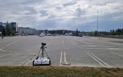
Mapping utility networks in the city of Kuopio, Finland
There is a large shopping center in the city of Kuopio, at Ratarinteenkatu 2. A large solar park will be built next to it, which will supply the center with affordable and environmentally friendly electricity. The solar park will be built behind the center, partly on...
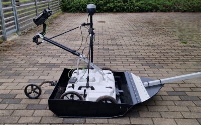
Multichannel GPR surveys now also in large areas
We are pleased to announce that from today we can also carry out GPR surveys with high-resolution 3D GPR on large meadows and farmland. All large-scale multichannel GPR surveys are now much faster and more affordable! All this is possible thanks to a new device that...
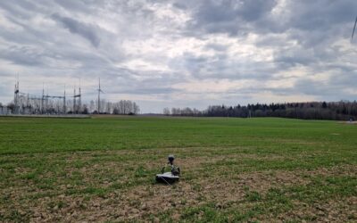
In 2025, we expanded our operations to Lithuania – the first GPR surveys were successfully completed!
We continue to expand our activities in neighboring countries and are pleased to announce that from the beginning of 2025 we will also offer GPR surveys in Lithuania. We have successfully completed our first projects in the Kelme and Mažeikiai regions, where we...